You already know wars are fought over oil. What you may not know is that the next generation of conflict has already begun — not with missiles, but with sluice gates. In May 2025, India weaponized a dam against Pakistan. China is building a 60-gigawatt reservoir capable of drowning India's northeast or turning it into a desert. The battlefield is the river. The weapon is the valve. And the war has no name yet because most people do not know it has started.
 Brajesh Mishra

For the last century, military doctrine has been obsessed with kinetics: how fast a missile flies, how accurately a drone strikes, how much armor a tank can pierce and while the world was busy counting warheads, the geography of conflict quietly shifted beneath our feet. While the era of "Resource Competition" is peaking, we have already entered the age of the Hydrological Siege.
In this new theatre of war, you don’t need to bomb a city to bring it to its knees. You don’t need to blockade a port to starve an economy. You simply need to control the flow and the opening shot of this new era was fired recently on the Asian continent.
In May 2025, in the wake of the Pahalgam terror attacks, New Delhi made a calculation that would have been unthinkable a decade ago. They didn't just scramble jets; they weaponized the map.
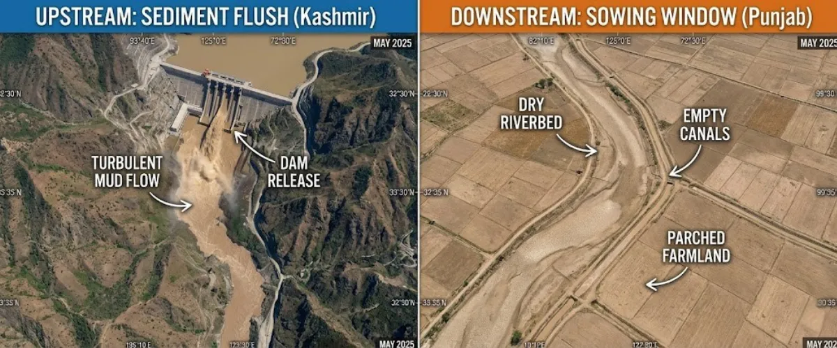
The target was the Chenab River and the weapon was the Baglihar Dam.
Deep in Indian-administered Kashmir, engineers executed what looked, on paper, like a routine technical procedure: a "sediment flush." They opened the sluice gates to purge millions of tons of silt, then slammed them shut to refill the reservoir but the timing was not accidental. It was synchronized perfectly with the Kharif sowing window in Pakistan’s Punjab; the precise moment when every drop of water is the difference between a harvest and a famine.
Downstream, in the Sialkot District of Pakistan, the result was chaos. First came the "Phantom Flood": a violent, unannounced surge of brown sludge that battered the riverbanks. Then, the river simply stopped. For forty hours, the Chenab flatlined, leaving the canals dry and the farmers staring at cracked earth.
This was the debut of the "Dry-Surge" doctrine. By turning a technical maintenance schedule into a strategic lever, India demonstrated that in the 21st century, the most effective siege weapon isn't a blockade but a valve.
To understand why a valve in Kashmir can starve a village in Punjab, you have to stop looking at borders and start looking at gravity. In the Himalayas, sovereignty is a vertical concept.
We are witnessing the calcification of a "Chain of Pain" that descends from the roof of the world to the ocean.
At the top of this hierarchy sits China, the "Upstream Hegemon." On paper, this seems like a paradox. Hydrological data shows that China contributes only about 30% of the Brahmaputra’s total volume, while the Indian monsoon provides the rest, but hydro-hegemony isn't about volume; it is about leverage. Beijing sits at 4,000 meters above sea level. They control the "base flow" during the dry lean season (when the monsoon fails) and they possess the "potential energy" of the river. They may not own all the water, but by sitting at the source, they own the trigger. They can hold back the critical dry-season flow or release a "water bomb" of sudden surges. They don't need to own the ocean to drown the coast; they just need to control the tap.
In the middle lies India, the "Middle Power." New Delhi occupies a precarious dual role. To the east, on the Brahmaputra, it is a nervous lower riparian, constantly scanning the horizon for Chinese floods. Yet to the west, on the Indus, it is the undisputed hegemon over Pakistan. India is the switchboard operator of the Himalayas, squeezed by the giant above, but holding the lifeline of the nation below.
And at the bottom lies Pakistan, trapped in the "Geography of Guilt." It is a nation where 95% of the water resources originate outside its own borders. It is the ultimate downstream hostage. For Islamabad, water security isn’t about rain; it’s about the political mood in New Delhi.
The terrifying physics of this new world order is simple: The nation upstream holds the kill switch. They can starve you with a drought, drown you with a flood, or simply blind you by withholding the data. And as gravity dictates, the water and the power, only flows one way.
While the world worries about nuclear buttons, New Delhi realized it had a much cheaper, more plausible option: The Maintenance Schedule. This is the doctrine of "Hydro-Tactics." The genius of this strategy is its deniability. You don't need a mega-dam to cripple an enemy economy; you just need a calendar.
The weaponization of maintenance relies on a technical loophole. Dams like Salal and Baglihar on the Chenab River accumulate vast amounts of silt. To keep them running, you have to flush them. Under the 1960 Indus Waters Treaty, India is allowed to do this. But the treaty never specified when.
So, India weaponized the "When."
By synchronizing the "sediment flushing" protocol, it opened the gates to release a wall of silt, then closed them to refill the reservoir, with the critical Kharif sowing window in Pakistan. India turned a routine engineering task into an economic offensive. It is the perfect gray-zone attack. When Pakistan complained, India simply pointed to the technical manual: “We are just cleaning the pipes.”
But the gloves truly came off in April 2025.
That month marked the "Abeyance" of the Indus Waters Treaty. For decades, this treaty was the firewall between water and war. But after repeated cross-border terror incidents, New Delhi signaled a shift from cooperation to coercion. The message to Islamabad was brutal in its simplicity: Blood and water cannot flow together.
By suspending the treaty's dispute resolution mechanisms, India effectively removed the referee from the field. Now, every drop of water that flows into Pakistan is no longer a right; it is a gift. And gifts can be withheld.
If India is playing a tactical game with valves, China is building a doomsday machine with concrete. While New Delhi tweaks the flow, Beijing is rewriting the geography. We are moving from the tactical to the Structural. The epicenter of this escalation is the "Great Bend" of the Yarlung Tsangpo (Brahmaputra), just before it enters India.
Here, China is constructing the Medog Super-Dam.
The scale of this project is terrifying. It is designed to harness a 2,000-meter vertical drop in the riverbed. Its projected capacity is 60 Gigawatts—that is three times the size of the Three Gorges Dam, currently the world's largest. But for India, this isn't a power plant. It is a loaded gun pointed at the Northeast.
The Medog project gives Beijing two existential levers: The Dry Weapon: They can divert the flow North, turning the Brahmaputra in Assam into a seasonal trickle, destroying the ecosystem and the economy of the plains. The Wet Weapon: The "Water Bomb" thesis. In a conflict scenario, China could release a sudden, catastrophic surge from the reservoir, washing away India's border infrastructure and low-lying cities.
New Delhi knows it cannot stop the construction. So, it is forced to play a desperate game of "Dam-for-Dam." To counter the Medog threat, India has fast-tracked the Siang Buffer Project—a massive reservoir in Arunachal Pradesh designed to catch and absorb a Chinese "water bomb." But this defence comes at a terrible internal cost. To save the nation, the state must sacrifice the local land. The buffer project threatens to displace the indigenous Adi tribe and submerge their ancestral heartlands.
It is a tragedy of geopolitics: To defend against the neighbor upstairs, you have to drown your own basement.
Critics often dismiss the fear of the Medog Super-Dam as hawkish paranoia. They argue that China would never weaponize water on such a massive scale because of the diplomatic fallout. But we don't need to speculate about Beijing’s intentions. We have a case study to see India’s potential future, one only needs to look at Southeast Asia’s recent past. The Mekong River is the "Proof of Concept."
In 2019, the Lower Mekong Basin known as the rice bowl of Vietnam and Thailand suffered one of the worst droughts in living memory. The river turned an unnatural blue, indicating starvation as nutrient-rich sediment vanished. Farmers watched their crops wither and the ecosystem collapse. At an instant Beijing claimed it was a natural phenomenon, blaming low rainfall. But the data told a different story.
A landmark study by Eyes on Earth, using satellite data to measure "surface wetness," exposed the lie. The data revealed a shocking discrepancy: while the downstream nations were parched, the reservoirs in China’s Upper Mekong (Lancang) were actually filling up.
.webp)
The Reality: During the wet season, Chinese dams held back a massive volume of water, preventing the natural flood pulse the region relies on. The Verdict: The drought wasn't meteorological; it was man-made. The Mekong crisis taught the world a brutal lesson: Beijing views transboundary rivers as sovereign assets, not shared resources. When faced with a choice between generating its own power or saving a downstream neighbor’s harvest, China will choose itself. They have effectively "privatized the monsoon."
Beyond the physical dams and the sediment flushes, there is an invisible weapon that is equally devastating: Data Denial. In the world of hydrology, data is survival. Downstream nations rely on upstream data—flow rates, rainfall levels, and discharge volumes—to predict floods and manage droughts. Without this information, a nation is flying blind.
This is the "Psychological Siege." By withholding hydrological data, the upstream hegemon forces the downstream state into a permanent posture of anxiety. You never know if the river rising is a natural rainstorm or the prelude to an attack.
We have seen the weaponization of data evolve in three distinct phases: 2017 (Doklam): During the military standoff at the Doklam plateau, China abruptly stopped sharing hydrological data for the Brahmaputra and Sutlej rivers. For months, India’s flood management systems were blinded during the critical monsoon season. 2020 (Galwan): Following the deadly clashes in Galwan Valley, the data feed went dark again. It was a clear signal: political disputes will be fought on the river map. 2025 (Sindoor): The tables turned. In a retaliatory move following the "Abeyance" of the treaty, India cut the hydrological feed to Pakistan regarding the Western Rivers.
The outcome is a state of "Strategic Blindness." Governments are forced to spend billions on redundant radar and satellite monitoring simply to know what is coming down the mountain. The trust is gone. The river is no longer a connector; it is a vector of fear.
The Hydro-Siege isn't a localized anomaly in the Himalayas; it is fast becoming the dominant blueprint for 21st-century geopolitics. Across the globe, geography is being weaponized as upstream nations realize that a dam is more powerful—and harder to bomb—than a nuclear silo. We are witnessing the rise of a new class of superpower: the "Hydro-Hegemon."
The Nile Crisis: The Existential Threat If you want to see the future of the Brahmaputra, look at the Nile. For 5,000 years, Egypt was the master of the river. But in the last decade, the center of gravity shifted south to Ethiopia. The construction of the Grand Ethiopian Renaissance Dam (GERD) fundamentally broke the old order. The Weapon: The GERD's reservoir is massive enough to hold the Nile’s entire flow for over a year. The Threat: For Cairo, this isn't about electricity; it is about survival. Ethiopia now has the physical capacity to turn Egypt into a desert. In diplomatic backchannels, this is referred to as the "Blue Button"—the ability to choke a downstream civilization without firing a shot.
.webp) The Anatolian Valve: The Political Threat In the Middle East, Turkey has quietly built the ultimate geopolitical lever: the Southeastern Anatolia Project (GAP). By constructing 22 dams on the Tigris and Euphrates rivers, Ankara has effectively seized control of the water supply for Syria and Iraq. The Result: The marshlands of Southern Iraq—the biblical Garden of Eden—are turning into salt pans. The message from Ankara is consistent with the new global doctrine: Water is a sovereign asset, not a shared inheritance. The lesson for the world is stark: If you live downstream, your sovereignty is conditional.
The Anatolian Valve: The Political Threat In the Middle East, Turkey has quietly built the ultimate geopolitical lever: the Southeastern Anatolia Project (GAP). By constructing 22 dams on the Tigris and Euphrates rivers, Ankara has effectively seized control of the water supply for Syria and Iraq. The Result: The marshlands of Southern Iraq—the biblical Garden of Eden—are turning into salt pans. The message from Ankara is consistent with the new global doctrine: Water is a sovereign asset, not a shared inheritance. The lesson for the world is stark: If you live downstream, your sovereignty is conditional.
The history of human conflict is the history of resources. We spent the 20th century fighting over things we burn: oil, coal, gas. We built our alliances, our economies, and our fleets to secure the flow of energy. But the 21st century has shifted the axis. We will spend the next hundred years fighting over things we drink. The "Blue Cold War" is no longer a prediction; it is the operating system of Asia and the world. The treaties that held the peace for decades from the Indus Waters Treaty to the Mekong Agreement—are either dead or dying. They were built for a world where rivers were viewed as a "Global Commons." That world is gone. In this new era, the river is a sovereign asset. It is a battery for the upstream power, a weapon for the military strategist, and a hostage for the downstream nation. As the glaciers melt and the populations rise, the "Chain of Pain" will only tighten. The next great war may not start with a border incursion or a terror attack. It will start with the quiet closing of a sluice gate, and the terrifying silence of a drying river.
.webp)


Sign up for the Daily newsletter to get your biggest stories, handpicked for you each day.


 Trending Now! in last 24hrs